Guide to Mount Baldy hiking trail, L.A.'s best hike
Simply put, Los Angeles is my favorite American city for outdoor adventures, and especially hiking. Okay, so perhaps I’m biased, since this is home after all. However, you’ll really be hard-pressed to find such good, convenient hiking in any other city in America. I dare you to try. And while I recently shared about a few of my favorite Los Angeles hikes, today I’m coming to you with what I think is Los Angeles’ best hike, Mount Baldy (actually named Mount San Antonio). I just recently did the Mount Baldy hiking trail for the second time, and was reminded of how great of a California hike it is. And, what an ass-busting Los Angeles hike it is. In fact, I’m going as far to call it Los Angeles’ best hike, and one of the best hikes in Southern California, if not one of the best hikes in all of California.
And here’s why: It feels like a proper hike, covering approximately 11 miles and nearly 4,000 feet of elevation gain, and with great views at nearly every single turn. Many hikes in Los Angeles just feel like steady walks uphill. But I’d get more of a workout by just going to the gym.
Mount Baldy, however, is uphill the entire way, increasing in difficulty along the way, and a last stretch that makes for a challenge for any level of hiker. The reward is that 10,069-foot panoramic summit, followed by the mid-mountain beer at the ski lodge overlooking the mountains on the way down.

But being an 11-mile uphill hike with 4,000 feet of elevation gain, Mount Baldy isn’t a hike you just decide to do after lunch. Nor is it one you can show up unprepared for, like some Los Angeles hikes. You’ll want to give yourself 7 hours, though I’d plan for 8. That means that you’ll have to start before noon if you want to be down the mountain by sunset.
Before you arrive at the trailhead, you’ll first need to buy a permit from the Mt. Baldy Visitor Center (it’s on the way to the trailhead), which costs $5 per day, or use the annual Adventure Pass, which is $30, and permits access to Southern California’s four national forests. I then recommend taking Mt. Baldy Road up to Manker Campground and parking along the road (you’ll see tons of other cars parked along the road). The trail goes up Falls Road to San Antonio Falls, which even when I was there last week (mid-August), was flowing and could be heard from a distance.
To get to the top of Mount Baldy, there are a couple routes. One shoots off San Antonio Falls, heading up to the San Antonio Ski Hut. The main path continues toward the ski lift and up to Mount Baldy Notch. You can actually take the lift up to Mount Baldy Notch and cut some time off the hike, but I’m a purist, and would just assume do the entire thing. However, I know some people will hike up and then take the lift down.

I highly recommend stopping at Top of the Notch, which has a restaurant, bar and patio with amazing views, to take a break, fuel up with some snacks and power bars, and refill your water bottles. Resist the temptation for that beer, however, because the hike is about to get tougher.
From Top of the Notch, there are a number of ski runs that go up toward the summit. I suggest taking the run directly across from the main trail you came up to the lodge on. You’ll take it up and make a left, where you‘ll see a wooden fence that runs up the trail. Follow that up. Be prepared, however, as this is one of the steepest parts of the hike, and leads to Devil’s Backbone, which has some of the narrowest sections of the hike. In other words, be careful, take lots of breaks, and take extra consideration of other hikers and runners who you encounter.

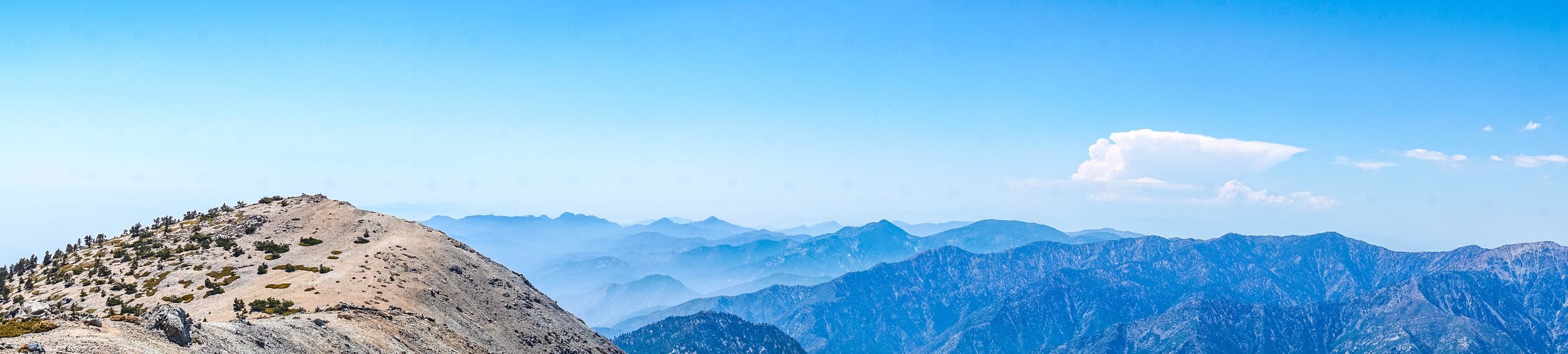
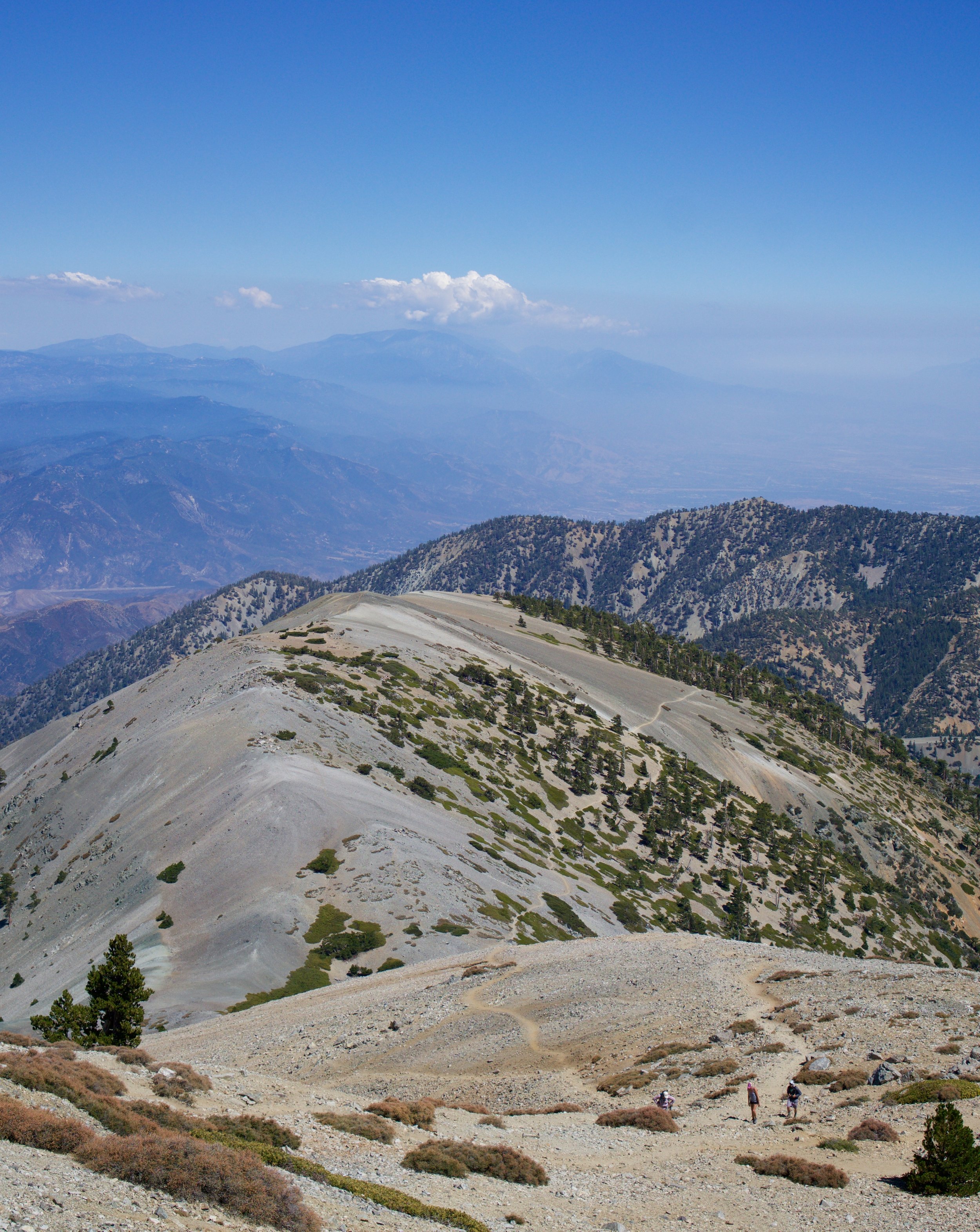
Finally, the trail opens up and there is Mount Baldy's summit in front of you. You’re on the home stretch. Take a breath, right? Well kind of. You’re that much closer to 10,000 feet, so you simply don’t have the oxygen that have at sea level, nor the amount of oxygen when you started the hike. As such, take it slow and take numerous breaks. As you ascend, there are a number of different offshoot trails for the last climb, but they all lead up to the top.
And then, after many hikers on their way down have cheered you onward and said that you’re almost there, you make it. The highest peak in Los Angeles County, standing at more than 10,000 feet high. The view atop Mount Baldy/Mount San Antonio is unparalleled, with unobstructed views across Southern California, looking down on some of the area’s most prominent peaks. Enjoy a snack, drink some water (though save some for the walk down), and if you’re going to take one selfie, I guess it would suffice to do so here.
On the hike down, I always stop at Top of the Notch for a beer. You’ll be hard-pressed to find a better après-hike view in California, plus they have a good selection of local and regional craft beers. From Top of the Notch, it’s really a nice walk down back to the bottom. Your work is done.
By and large, people of all ages and different fitness levels can do this Los Angeles hike. I’ve seen everyone from older kids to older couples doing the hike. Nonetheless, depending on your fitness level, you may consider brining trekking poles, which I see people often using on the hike. Find a few other important Mount Baldy hiking tips below.

Mount Baldy Hiking Tips
1. Do not hike Mount Baldy during the winter. I’m going to be frank here, just don’t hike Mount Baldy during the winter under any circumstances. The last couple winters has seen several deaths from people hiking it during winter.
2. Take tons of water.Tons of water. I recommend at least two to three liters of water. I often have a water bladder, plus an additional water bottle, and refill both at Top of the Notch (on the way up and down), since there is nowhere else to refill.
3. Start hiking Mount Baldy as early as possible. I recommend starting the Mount Baldy hike as early as possible. That way you’ll be able to get some shade at parts and not be hiking up during the hottest part of the day. Plus, you’ll be encountering far less people. Nonetheless, on my most recent hike, it was nice hiking later in the day, and having so much shade on the last section down after Top of the Notch. Plus, I encountered very few people since it was too late in the day for people to do the hike.
4. Pack layers. With 4,000 feet of elevation gain and a 10,000-foot summit, Mount Baldy’s conditions can change quickly. As such, pack some layers in your day bag. When I went a couple weeks ago, I lucked out with it being about 80 degrees at the trailhead, and never getting too cool or windy until I made the top of the summit.
5. Wear a good pair of hiking boots and hiking shoes. Hiking boots! Not hiking shoes, trail running shoes, or sandals, but actual boots. Your feet will thank you. Plus, you’ll be less likely to slip on some of the steeper sections on your way down the mountain.
6. Call/text friends or family before you get to Mount Baldy. Don’t plan on having service at any point of your Mount Baldy hike. Most recently, I got service for about one minute, and even then, was unable to send texts. Especially if you’re hiking solo, I’d recommend texting or calling a friend or family member, since you’ll be out of service for hours.